Santiago Plan
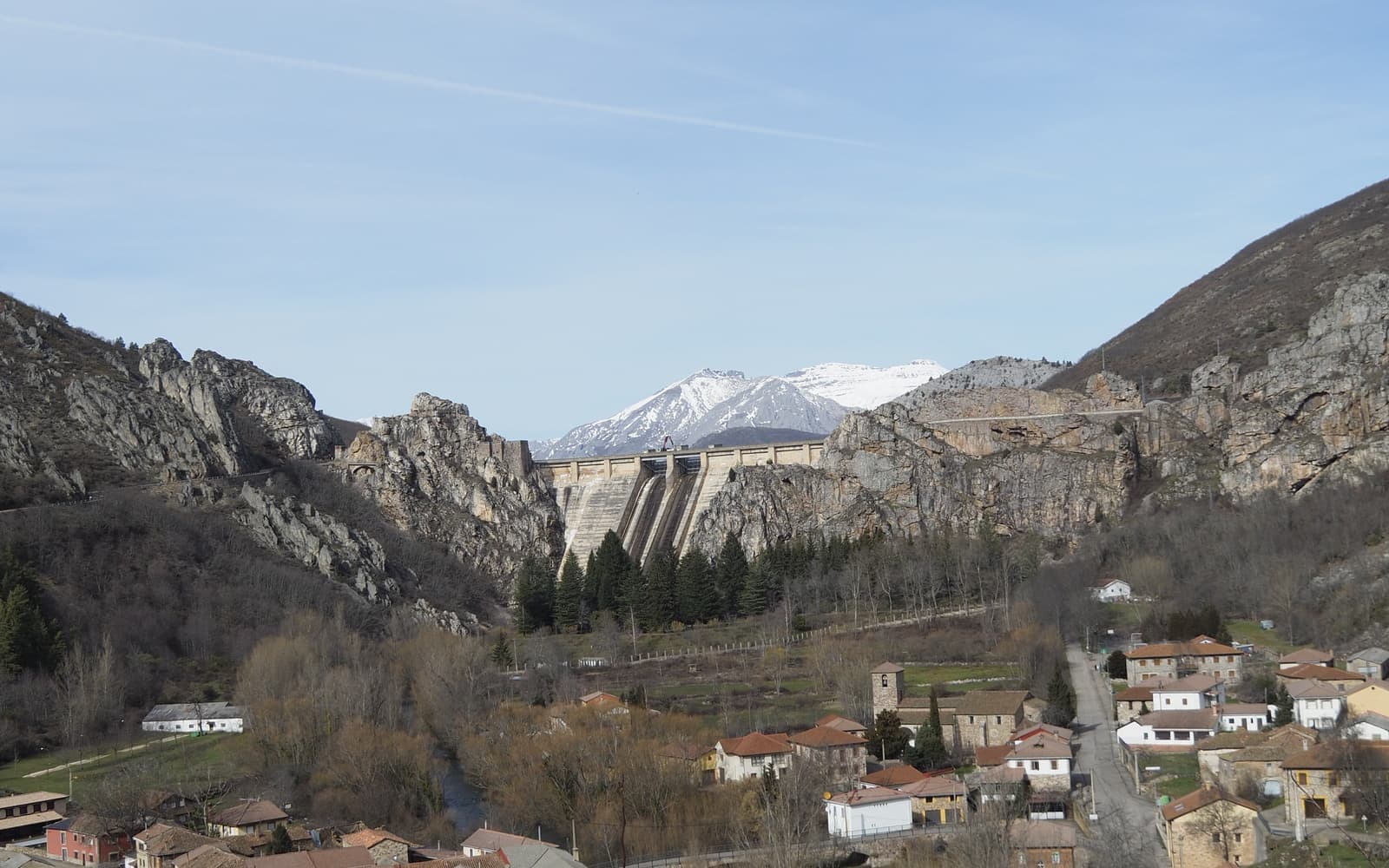
Mountains of the Camino Olvidado
© José Manuel Guerrero · Fotografía propia · © Todos los derechos reservados

El Camino Viejo de la montaña

Camino Olvidado

Older than the French Way itself: the mountains of Palencia and León, empty villages and utter silence, for those seeking extreme solitude.

✦ Historic
Distance
≈ 450–480 km
Days
22
Difficulty
Moderate
Terrain
Mountains, valleys and inland villages

Elevation profile

↑ Ascent

+8151 m

↓ Descent

−7672 m

-24889120300 km118 km235 km353 km470 km

The Camino Olvidado links Bilbao with Villafranca del Bierzo through the mountains, avoiding the meseta. It is one of the oldest Jacobean routes: between the 9th and 11th centuries it was the main way to Santiago, when the unsafe Duero valley and Almanzor's campaigns ruled out the lowland route.

It lost prominence in the late 11th century, when the frontier moved south of the Duero and Alfonso VI promoted the Camino Francés together with the monks of Cluny. It stayed forgotten until its recent revival: Castilla y León recognised it as a Historic Route in December 2020. Palencia and León mountains, empty villages and silence.

Who it's for

For the pilgrim in search of extreme solitude and heritage.

The itinerary

Stages of the route

Classic division into stages. Distances are approximate and for guidance; each pilgrim adjusts their days to their own pace.

  1. 0122 km

    Cumulative: 22 km

    ↑361 ↓289 m⏱ 5 h 50 min

    Biscay

    Bilbao → Mimetiz (Zalla)

    You leave Bilbao's estuary behind and head into Las Encartaciones, through woodlands and quiet little valleys.

    View stage →
  2. 0223 km

    Cumulative: 45 km

    ↑510 ↓292 m⏱ 6 h 20 min

    Biscay · Burgos

    Mimetiz → Villasana de Mena

    You cross into Burgos through the Valle de Mena, a green, sheltered landscape.

    View stage →
  3. 0326 km

    Cumulative: 71 km

    ↑575 ↓132 m⏱ 7 h 9 min

    Burgos

    Villasana de Mena → Espinosa de los Monteros

    Villages of noble stone in Las Merindades, the cradle of Castilian lineages.

    View stage →
  4. 0421 km

    Cumulative: 92 km

    ↑282 ↓364 m⏱ 5 h 28 min

    Burgos

    Espinosa de los Monteros → Santelices

    A peaceful stage among the hills of Las Merindades, little travelled and wonderfully authentic.

    View stage →
  5. 0525 km

    Cumulative: 117 km

    ↑492 ↓321 m⏱ 6 h 46 min

    Burgos

    Santelices → Arija

    You draw near the source of the Ebro and the great reservoir that bears its name.

    View stage →
  6. 0629 km

    Cumulative: 146 km

    ↑611 ↓436 m⏱ 7 h 55 min

    Cantabria

    Arija → Olea

    You skirt the Ebro reservoir, a strikingly photogenic landscape of water and mountains.

    View stage →
  7. 0721 km

    Cumulative: 167 km

    ↑221 ↓337 m⏱ 5 h 22 min

    Cantabria · Palencia

    Olea → Aguilar de Campoo

    You arrive in Aguilar de Campoo, famed for its biscuits and its Romanesque collegiate church.

    View stage →
  8. 0827 km

    Cumulative: 194 km

    ↑226 ↓132 m⏱ 6 h 48 min

    Palencia

    Aguilar de Campoo → Cervera de Pisuerga

    You approach the Montaña Palentina, with the Picos de Europa rising in the distance.

    View stage →
  9. 0920 km

    Cumulative: 214 km

    ↑289 ↓148 m⏱ 5 h 15 min

    Palencia

    Cervera de Pisuerga → Tarilonte de la Peña

    A short, green stage beside the Requejada reservoir, perfect for a restful day.

    View stage →
  10. 1017 km

    Cumulative: 231 km

    ↑166 ↓211 m⏱ 4 h 19 min

    Palencia

    Tarilonte de la Peña → Guardo

    A mining landscape gives way to the first foothills of the Cantabrian Mountains.

    View stage →
  11. 1113 km

    Cumulative: 244 km

    ↑204 ↓321 m⏱ 3 h 26 min

    Palencia · León

    Guardo → Puente Almuhey

    You cross into León through a quiet district of small cattle-farming villages.

    View stage →
  12. 1219 km

    Cumulative: 263 km

    ↑428 ↓458 m⏱ 5 h 14 min

    León

    Puente Almuhey → Cistierna

    You enter León's central mountains, close to the Riaño and Porma reservoirs.

    View stage →
  13. 1322 km

    Cumulative: 285 km

    ↑385 ↓358 m⏱ 5 h 53 min

    León

    Cistierna → Boñar

    Leonese mountain scenery, with the Curueño keeping you company for much of the way.

    View stage →
  14. 1419 km

    Cumulative: 304 km

    ↑251 ↓232 m⏱ 4 h 57 min

    León

    Boñar → Robles de la Valcueva

    A transitional stage towards León's mining basin, through green valleys.

    View stage →
  15. 1513 km

    Cumulative: 317 km

    ↑124 ↓162 m⏱ 3 h 18 min

    León

    Robles de la Valcueva → La Robla

    A short, easy stage and a fine chance to discover the area's mining heritage.

    View stage →
  16. 1617 km

    Cumulative: 334 km

    ↑346 ↓323 m⏱ 4 h 37 min

    León

    La Robla → La Magdalena

    You follow the course of the River Luna along a gentle, well-waymarked stretch.

    View stage →
  17. 1713 km

    Cumulative: 347 km

    ↑215 ↓135 m⏱ 3 h 27 min

    León

    La Magdalena → Riello

    You enter the Omaña district, green and seldom walked by pilgrims.

    View stage →
  18. 1827 km

    Cumulative: 374 km

    ↑512 ↓254 m⏱ 7 h 17 min

    León

    Riello → Fasgar

    A demanding mountain stage, one of the most beautiful and solitary on the whole Olvidado.

    View stage →
  19. 1932 km

    Cumulative: 406 km

    ↑769 ↓1175 m⏱ 8 h 54 min

    León

    Fasgar → Igüeña

    A descent towards El Bierzo through age-old oak and chestnut woods.

    View stage →
  20. 2016 km

    Cumulative: 422 km

    ↑299 ↓402 m⏱ 4 h 18 min

    León

    Igüeña → Labaniego

    The mining landscape of El Bierzo, with old coal workings standing witness.

    View stage →
  21. 2114 km

    Cumulative: 436 km

    ↑316 ↓433 m⏱ 3 h 52 min

    León

    Labaniego → Congosto

    You approach the Boeza valley, now in the very heart of El Bierzo.

    View stage →
  22. 2218 km

    Cumulative: 454 km

    ↑379 ↓509 m⏱ 4 h 55 min

    León

    Congosto → Cabañas Raras

    The vineyards of El Bierzo herald the nearness of Villafranca and the Camino Francés.

    View stage →
  23. 2317 km

    Cumulative: 471 km

    ↑190 ↓248 m⏱ 4 h 22 min

    León

    Cabañas Raras → Villafranca del Bierzo

    The final stage: you reach Villafranca, where the Olvidado merges with the Francés.

    View stage →

Plan your daily stages

Choose which stage you start from, how many days you have and at what pace; we split the stages into days balanced by effort (distance and elevation). You can save, share or print your plan.

Pace

23 days · ≈ 471 km in total

One or more days exceed 32 effort units (kilometres plus climb: 100 m of ascent count as 1 km). Doable if you are fit, but consider adding a day.

  1. Day 1Stage 1
    Bilbao → Mimetiz (Zalla)View stage 1 ↗
    ≈ 22 km+361 m
  2. Day 2Stage 2
    Mimetiz → Villasana de MenaView stage 2 ↗
    ≈ 23 km+510 m
  3. Day 3Stage 3
    Villasana de Mena → Espinosa de los MonterosView stage 3 ↗
    ≈ 26 km+575 m
  4. Day 4Stage 4
    Espinosa de los Monteros → SantelicesView stage 4 ↗
    ≈ 21 km+282 m
  5. Day 5Stage 5
    Santelices → ArijaView stage 5 ↗
    ≈ 25 km+492 m
  6. Day 6Stage 6
    Arija → OleaView stage 6 ↗
    ≈ 29 km+611 mDemanding day
  7. Day 7Stage 7
    Olea → Aguilar de CampooView stage 7 ↗
    ≈ 21 km+221 m
  8. Day 8Stage 8
    Aguilar de Campoo → Cervera de PisuergaView stage 8 ↗
    ≈ 27 km+226 m
  9. Day 9Stage 9
    Cervera de Pisuerga → Tarilonte de la PeñaView stage 9 ↗
    ≈ 20 km+289 m
  10. Day 10Stage 10
    Tarilonte de la Peña → GuardoView stage 10 ↗
    ≈ 17 km+166 m
  11. Day 11Stage 11
    Guardo → Puente AlmuheyView stage 11 ↗
    ≈ 13 km+204 m
  12. Day 12Stage 12
    Puente Almuhey → CistiernaView stage 12 ↗
    ≈ 19 km+428 m
  13. Day 13Stage 13
    Cistierna → BoñarView stage 13 ↗
    ≈ 22 km+385 m
  14. Day 14Stage 14
    Boñar → Robles de la ValcuevaView stage 14 ↗
    ≈ 19 km+251 m
  15. Day 15Stage 15
    Robles de la Valcueva → La RoblaView stage 15 ↗
    ≈ 13 km+124 m
  16. Day 16Stage 16
    La Robla → La MagdalenaView stage 16 ↗
    ≈ 17 km+346 m
  17. Day 17Stage 17
    La Magdalena → RielloView stage 17 ↗
    ≈ 13 km+215 m
  18. Day 18Stage 18
    Riello → FasgarView stage 18 ↗
    ≈ 27 km+512 mDemanding day
  19. Day 19Stage 19
    Fasgar → IgüeñaView stage 19 ↗
    ≈ 32 km+769 mDemanding day
  20. Day 20Stage 20
    Igüeña → LabaniegoView stage 20 ↗
    ≈ 16 km+299 m
  21. Day 21Stage 21
    Labaniego → CongostoView stage 21 ↗
    ≈ 14 km+316 m
  22. Day 22Stage 22
    Congosto → Cabañas RarasView stage 22 ↗
    ≈ 18 km+379 m
  23. Day 23Stage 23
    Cabañas Raras → Villafranca del BierzoView stage 23 ↗
    ≈ 17 km+190 m

An indicative split by effort (distance + elevation). It does not guarantee accommodation at each stop: check each stage and its hostels before finalising your plan.

✦ Add stamps to your digital credential

Save this route to your account, mark each stage you complete and earn your virtual Compostela when you reach Santiago. Free.

The stamps and the digital credential are a keepsake from Santiago Plan, with no official validity: they are not the pilgrim credential and do not replace the physical stamps collected at hostels and churches to obtain the Compostela at the Cathedral.

🛡 Travel insurance for the Camino

Insurance with medical assistance, baggage cover and cancellation protects you against the unexpected: an injury, a mishap or a stage you can't walk. IATI specialises in travel and offers cover valid for the Camino de Santiago.

See IATI insurance ↗

Affiliate link: taking it out through it costs you no more and helps keep this guide independent.

The route

The route

Approximate track of the route with the towns it passes through.

Layers

Use two fingers to move the map; Ctrl + scroll to zoom.

Download and offline navigation

Download the GPX track and open it in your hiking app (OsmAnd, Wikiloc, Locus…) to navigate without coverage.

Download GPX

Where to sleep

Accommodation and services, stage by stage

A selection of pilgrim hostels (albergues) along the Camino, ordered from the start towards Santiago. The municipal and parish ones are usually the cheapest and many cannot be booked (you arrive and check in in order). Confirm beds, price and opening times before relying on them.

3. Espinosa de los Monteros

Villasana de Mena → Espinosa de los Monteros

Hotels and guesthouses ↗
4. Santelices

Espinosa de los Monteros → Santelices

Hotels and guesthouses ↗
9. Tarilonte de la Peña

Cervera de Pisuerga → Tarilonte de la Peña

Hotels and guesthouses ↗
12. Cistierna

Puente Almuhey → Cistierna

Hotels and guesthouses ↗
15. La Robla

Robles de la Valcueva → La Robla

Hotels and guesthouses ↗
23. Villafranca del Bierzo

Cabañas Raras → Villafranca del Bierzo

Hotels and guesthouses ↗

Hostel data © OpenStreetMap contributors (ODbL). It does not include beds or price, which are not always in the source; check with the hostel. Is one missing or wrong? Write to us.

Accommodation

Hotels and guesthouses

On the Camino, pilgrim hostels (municipal, parish and private) are the cheapest option, and many cannot be booked: you arrive and check in in order of arrival. The links below search for hotels and guesthouses, for those who prefer to secure a bed in advance.

Affiliate links to Booking.com: booking through them costs you no more and helps keep this independent guide running.

When you reach Santiago

Experiences and guided tours in Santiago

When you finish your Camino, make the most of Santiago: a guided tour of the cathedral and the botafumeiro, a trip to Finisterre and Muxía (the end of the world), or the corners of the old town.

See experiences in Santiago ↗

Affiliate link to GetYourGuide: booking through it costs you no more and helps keep this guide running.

🧭 How to get there

Find out how to travel from your city to Bilbao by train, bus, car or plane.

Open in Google Maps →Links to external planners; schedules and prices on their website.

Frequently asked questions

How many kilometres is the Camino Olvidado?
The Camino Olvidado is about 450480 km and usually takes around 22 days on foot.
Is the Camino Olvidado hard?
Its difficulty is moderate. On Santiago Plan you have every stage with a map, elevation profile and hostels, so you can prepare it calmly.
How much does it cost to walk the Camino Olvidado?
Staying in hostels, budget roughly between 550 and 990 € in total (around 22 days), including bed, food and the odd extra. It varies with the season and your travel style.
Do you need to book the hostels?
In low season it's usually not necessary, but in summer and during a Holy Year it's wise to plan ahead and, in many cases, book your accommodation. We can't guarantee bed availability.

Xacobeo 2027

Planning the Camino Olvidado?

Leave your email and we will send you news, tips and deals to prepare this route in good time. No spam.

Other routes

See all →